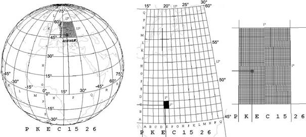
World Geographic Reference System (GEOREF)
The World Geographic Reference System a search network partitioning the Earth surface into even smaller geographic quadrangles by which a small territory can be appointed and identified. The Earth is divided up primarily into 24 coincident ellipsoidal lunes – so called „zones” – (figures bounding by meridians with differences of 15°) which are marked by the letters of the english big alphabet from A to Z (omitting I and O). Every such zone is divided into 12 geographic quadrangles with a latitude difference of 15° and this quadrangles are marked northward by the english big alphabet from A to M (omitting I). This divisions provide a partition of the Earth surface into 12 geographic quadrangle of 15°x15°. The two letters jointly identify the field of 15°x15°. E.g. Hungary is located in the quadrangle marked by PK.
The fields of 15°x15° are split up into subfields of 1°x1°. Their identifier is composed of two letters: the first letter identifies the column of 1° eastwards from A to Q (omitting I and O), and the second letter identifies the row of 1° northwards from A to Q (omitting I and O), too. E.g. Budapest (~47.5° N, ~19° E) lays in the subfield marked by EC of the field PK.
The subfields of 1°x1° are partitioned into sub-subfields of 1’x1’ which are identified by the geographic coordinates of their southwestern corner of the sub-subfield rounded to minutes. Consequently, the sub-subfield containing the point „Liszt Ferenc Airport 2” identified by the geographic coordinates 47° 26’ 22” North, 19° 15’ 43” East gets the attribute „15 26”. The GEOREF coordinate can be made more accurate by giving the value of the minute to the first or second decimal. So the last attribute is 157 263 or 1572 2637.
The search network GEOREF was developed for the US Air Force. Nowadays, the international aeronavigation uses it for location of airports and reporting the position of aeroplanes.