Location identifying and reporting system MGRS (Military Grid Reference System)
This system assigns a code to every geographic point and identifies it for military or navigation purposes, with a high degree of accuracy. It is based on the partition of the UTM zones into geographic quadrangles of 6°x8° on the one hand, and uses the UTM map coordinates on the other. It gives a possibility to appoint a UTM map square of 100x100 km and including an Earth point with an accuracy of 1m.
A UTM zone of 6° represents a territory which is about 667 km wide by the Equator. The mid-meridian of the zone corresponds to the UTM’s Y coordinate-line of 500000 m, and four columns with a width of 100000 m both westwards and eastwards, cover the whole zone. Furthermore, the zone is partitioned into rows with a width of 100000 m by X coordinate lines parallel with the Equator (XUTM=0.0 m). The columns and rows together create a grid of 100kmx100km. This partition is independent of the partition into geographic quadrangles of 6°x8° mentioned above.
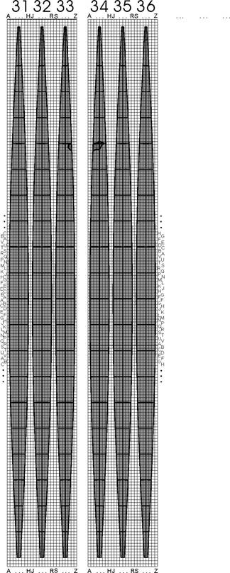
The UTM zones of 6° with its 800 km wide covering grid are grouped in sets of three, and the 3x8 columns of 100000 m are denoted by the capital letters of the English alphabet from A to Z (I and O are removed) eastwards. The notation of the 100 rows with a width of 100000 m happens in each zone both northwards and southwards by the capital letters of the English alphabet. In the zones with odd serial number, the rows are denoted by the 20 letters from A to V (I and O removed), starting from the Equator in both directions, recurrently 5 times up to the poles. In the zones with even serial number, the notation of the rows: FGHJ…UVABCDE (I and O removed), starting from the Equator in both directions, recurrently 5 times up to the poles.
The MGRS identifier is composed of three parts:
- the identifier of the geographic quadrangle of 6°x8° (serial number of the zone + letter notation of the band, e.g. 34T);
- the identifier of the square of 100 km x 100 km (letter notation of the column + letter notation of the row, e.g. CT)
- the last five numbers of the two UTM coordinates truncated to meters, inside of the square of 100 km x 100 km (coordinate Y + coordinate X, alltogether 10 digits, e.g. 34T CT 54053 59662).
The UTM coordinates can be restored based on the MGRS identifier in the following way. The UTM coordinates of the lower left corner of the square of 100kmx100km is rounded off to the nearest 100000 meter. It can be determined from its identifier denoted by a pair of letters. The following 2x5 digits provide the last 5 digits of the UTM coordinates.
The territory of Hungary takes up its position on the eastern edge of the merged 31-33 zones, in the columns marked by W, X and Y, and in the rows marked by L, M, N and P, in addition on the western edge of the merged 34-36 zones, in the columns marked by B, C, D, E and F, and in the rows marked by R, S, T, U and V.