Lecture notes – Chapter 4
Fitting the ellipsoid to the geoid
The astronomical coordinates of a point on Earth surface are – aside from the measurement errors – unambiguously defined on the geoid. The ellipsoidal geographic coordinates of the same point depend on the position of the ellipsoid related to the geoid, so the ellipsoid has to be fitted to the geoid. The coordinates of some selected triangulation stations, the so called Laplace points have been fixed both by astronomical and geodetical measurements (the latters refer to an ellipsoid). After the adjustment calculations and the reduction to the geoid, the ellipsoid will be determined by the minimisation of the sum of the squared angle differences between the vertical directions on the geoid and the ellipsoid („plumb-line deviation” or „deflection of the vertical”) in the Laplace points. This fitted ellipsoid is called the geodetic datum (or simply datum).
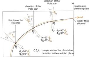
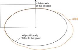
The surface of this ellipsoid and the geoid surface are approximately parallel in the environment of the Laplace points, so a locally fitted ellipsoid (e.g., SAD69 in Brazil, Schwarzeck in Namibia, Indian Geodetic Datum in India, Krassovsky 1940 in Kazakhstan, NAD83 in the USA, Carthage in Tunisia, HD72 in Hungary) will be created. The satellite geodesy enables to establish globally fitted ellipsoid, too (e.g., WGS84 datum).
The difference of the ellipsoidal height and the „normal height” (height above sea level) measured on the geoid is the „undulation of the geoid”. In the case of WGS84 datum, its value is between –106 m and 85 m.
Replacing the ellipsoid by sphere
Under the map scale cca. 1:1 million, the coordinate differences on the map caused by the eccentricity of the ellipsoid are smaller than the accuracy of the map (0.1–0.2 mm). So the geocartography uses rather spherical coordinates instead of ellipsoidal in order to simplify the projection calculations. The radius of the sphere can be calculated e.g. by the average of several values of meridian radius of curvature which varies depending on the latitudes of the points on the area of representation. An other usual simple approximation of the mean value of the radius R:
![]()
Some projections in the geodesy use an intermediate spherical surface (so called „aposphere”) between the ellipsoid and the plane. If the mapping is conformal, then the radius R of the osculating sphere, concerning the centre of the area to be represented with latitude Fs, is defined by the geometric mean of the meridian radius of curvature (M) and the radius of curvature normal to the meridian (N):
![]()
(see later).
Transformations of geographic coordinates between different reference surfaces
The Earth coordinates created in different times and in several circumstances refer to different ellipsoids, datums or substituting spheres. If these mixed coordinates are used together, they have to be integrated in a common reference system. It can be done by transforming the coordinates from a geodesic datum onto another one. In other cases the surface of the ellipsoid is approximated by sphere; on such occasions the coordinates of the ellipsoidal surface are transformed onto spherical coordinates or reversely.
Transformations between geographic coordinates of different datums
The geographic coordinates of Earth points originate – directly or indirectly – in geodesic measurements. Exact transformation between different geodetic datums doesn’t exist in general due to measuring errors and varied fitting of the ellipsoids, therefore divers approximating transformation methods were developed.
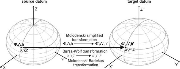
Three-parameter Molodenski simplified transformation between geographic coordinates of different datums
The rotation axes of the source and target datums are supposed parallel, and the transformation comes true by a translation of the origin in a spatial rectangular coordinate system, whose parameters are DX, DY, DZ. The difference Da of the semi-major axes (Da=atarget–asource) and also the difference Df of the flattenings (Df=ftarget–fsource), belonging to the datums in question are additionally used. The simplified formulae of the transformation are given in a way, which doesn’t require transformation between the geographic coordinates (+height above sea level) and the spatial rectangular coordinates to and from, so the calculations can be processed by formulae immediately with the geographic coordinates. Let the geographic coordinates (+ height) of the point to be transformed on the source and target datums, be denoted by F,L,h and F’,L’,h’. Then the differences DF=F’–F, DL=L’–L, Dh=h’–h generated by the transformation, are:
![]()
![]()
![]()
For the transformation of points located on a given territory, fitting points with coordinates known in both reference system are required. The DX, DY, DZ parameters characterizing the given territory can be calculated from this fitting points.
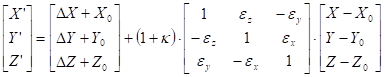
Seven-parameter Burša-Wolf transformation between spatial rectangular coordinates
The Helmert-transformation of spatial points is well-known in the field of geodesy. It is composed of a translation, three rotations and a similarity transformation. The seven parameters are: the components DX, DY, DZ of the translation vector, the rotation angles eX, eY and eZ about the axes, and the ratio (1+k) of the similarity transformation (scaling up or down). Supposing that the rotation angles are small, the formula below assigns the transformed coordinates X’, Y’, Z’ to the spatial point given by coordinates X, Y, Z:

If the source point is given by geographic coordinates (and by its height), then at first they have to be converted into spatial rectangular coordinates. After their transformation by formulae above, the obtained spatial rectangular coordinates can be re-converted into geographic coordinates (+height) by the formulae of Bowring or Borkowski. This is called Burša-Wolf transformation in the field of GIS.
Using this formula, the transformation of a point on a given territory also demands fitting points with coordinates known in both reference system. The parameters for translation, rotation as well as scaling up or down can be obtained from fitting points with help of adjustment calculations.
Ten-parameter Molodenski-Badekas transformation
This transformation takes the same conversions into consideration, as the previous one, but the centre of rotation axes and the similarity transformation is not the origin, but the centroid (that is the point with average coordinates of the triangulation network points on the territory to be represented). So:
where the coordinates of the centroid are:
 ,
,
 ,
, 
and the points with coordinates (Xi,Yi,Zi) (i=1,…,n) are triangulation network points.
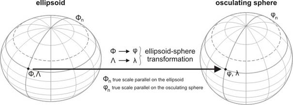
Transformation of the ellipsoid onto the sphere
The map projections which use the mentioned intermediate aposphere in the course of mapping from the ellipsoid onto plane, need a special built-in transformation, that is to say the mapping of an ellipsoid or its part onto a locally approximating sphere. The basic properties of this transformation are: the ellipsoidal parallels are projected onto spherical ones, otherwise: the spherical latitude depends only on the ellipsoidal latitude, that is j=j(F). Similarly, every ellipsoidal meridian is projected onto a spherical one, moreover the longitude differences on the ellipsoidal parallels have to be proportional to the differences on the sphere, which is expressed in the following formula: Dl=n×DL, where n is constant.
The distortions of this mapping can be derived from the scale distortions along the graticule, wich imply here the maximal and minimal scale distortions, because of the orthogonality of the graticule on both surfaces. Therefore – the formula for the scale distortion h along the parallels (denoting the arc lengths on the ellipsoid and the sphere by Dp and Dp’, respectively, which are generated by DL and Dl, respectively), is
![]()
Similarly, the formula for the scale distortion k along the meridians (denoting the arc lengths on the ellipsoid and the sphere by Dm and Dm’, respectively, which are generated by DF and Dj, respectively), is
![]()
Conformal projection of the ellipsoid onto the sphere
The property of conformality (or angle invariance), which means the preservation of angular relationships in the course of mapping from one surface to another, is a property which is tantamount to the equality of the maximum and minimum scale distortions in every point of the projected territory. The equation of the conformality: h=k, that is
![]()
The solution of this separable differential equation:
![]()
After transformation of the fraction and integration:
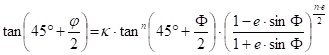
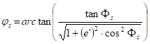
This formula allows the expression of the spherical latitude:
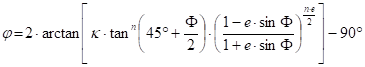
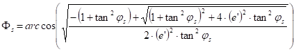
Reversaly, the ellipsoidal latitude can be calculated per iteration:
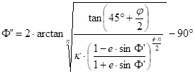 then
then ![]() until
until ![]() and
and ![]()
where e is the required accuracy of the calculation; finally F=F”. A possible initial value: F’=j .
The constants k and n depend on the aim of the map using the projection with this built-in mapping. If the complete Earth or its large part has to be represented, then it is needed that n=1. If the ellipsoidal Equator (F=0°) has to be mapped to the spherical Equator (j=0°), then this condition results k=1. The still missing radius of the target sphere can be obtained, if a true-scale parallel is prescribed. Let Fs be its latitude on the ellipsoid, and js on the sphere, then the scale distortion h along this parallel is:
![]()
and so
![]()
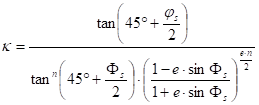
In other practical cases, when a smaller part of the ellipsoid is mapped to the spherical surface (e.g. by geodesic or topographic maps), a possible ambition can be that the scale distortion on the represented territory should be minimal. Gauss formulated the condition so that, if considering the logarithm of the linear scale, then the constant term, the first-order term and second-order term in its power series expansion should be equal to zero. This system of equations gives after a longer derivation the next three equations, containing the unknown variables Fs, js, n and R:
![]()
![]()
![]()
Giving one of them, the other three variables can be calculated. The true-scale latitude on the sphere (js) or on the ellipsoid (Fs) is given most frequently. From the second equation:
or
 ,
,
then from the two latitudes:
![]()
and
 ,
,
finally
![]()
Other analogous mappings from the ellipsoid to the sphere can be obtained by means of conditions similar to above equations, so e.g. projection with true-scale meridians or equivalent (equal-area) projection, which are used rather in the geocartography.